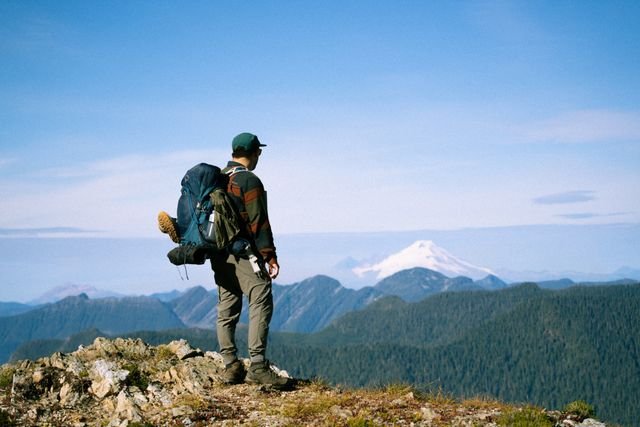
Ptarmigan Ridge Trail delivers huge Mount Baker views with alpine terrain, lingering snow, and a hike worth planning carefully.
The Ptarmigan Ridge Trail near Mount Baker, Washington, is a roughly 9-mile round-trip alpine hike from Artist Point, gaining about 1,800 feet and reaching approximately 6,100 feet. The trail is famous for close views of Mount Baker and Coleman Pinnacle, but lingering snow, rocky terrain, exposure to mountain weather, and route-finding beyond the main trail make conditions more serious than the mileage suggests.
What You'll Discover:
Why the Ptarmigan Ridge Trail Is Worth the Effort
There is an unusual quality to Ptarmigan Ridge: you gain access to genuinely high alpine scenery without first spending hours climbing through dense forest.
The trail begins at Artist Point, already around 5,075 feet above sea level. From there, the landscape opens quickly into rocky ridges, meadows and enormous views toward Mount Baker, making the hike feel more like a high-mountain expedition than a conventional forest day hike.
The trade-off is terrain. The route is rocky for much of its length, has little shade, and can hold snow well into summer. At this elevation, a forecast that looks comfortable in town can translate into cold, wind, cloud or snow on the ridge.
And that is the key to understanding this hike: Ptarmigan Ridge is not especially difficult because it is long; it is demanding because it puts you high in exposed alpine terrain.
Ptarmigan Ridge Trail at a Glance
| Detail | What to expect |
| Location | Mount Baker-Snoqualmie National Forest, Washington |
| Trailhead | Artist Point |
| Round trip | About 9 miles |
| Elevation gain | About 1,800 feet |
| High point | About 6,100 feet |
| Difficulty | Moderate to hard |
| Terrain | Rocky alpine trail, talus, snow patches |
| Shade | Very little |
| Dogs | Allowed on leash |
| Trailhead facilities | Vault toilets; no potable water |
| Recreation pass | Northwest Forest Pass or America the Beautiful pass |
These figures describe the established hiking route documented by Washington Trails Association. GPS recordings and individual route choices can produce somewhat different mileage, particularly if hikers continue beyond the commonly used destination.
Where the Trail Starts
The standard route begins at Artist Point, at the end of State Route 542, also known as the Mount Baker Highway.
From Bellingham, the drive follows SR 542 east through Glacier and onward toward Mount Baker. The final section reaches Artist Point at the end of the highway; WTA lists the trailhead at approximately 48.8463, -121.6927.
Artist Point is more than a parking area. It is the access point for several major trails, including Ptarmigan Ridge, Chain Lakes, Artist Ridge and Table Mountain. That means it is easy to start walking on the wrong trail if you are simply following the crowd.
For Ptarmigan Ridge, the route initially follows the Chain Lakes Trail before branching onto Ptarmigan Ridge.
What the Hike Is Actually Like
Artist Point to the Ptarmigan Ridge Junction
From the northwest corner of the Artist Point parking area, follow the Chain Lakes Trail.
After roughly 1.1 miles, the Ptarmigan Ridge route branches away. This opening section is relatively straightforward, but it is worth paying attention at the junction because several spectacular trails share the same starting area.
The trail then climbs over a ridge before dropping roughly 200 feet. That small descent is easy to underestimate: you have to climb it again on the return.
The Rocky Middle Section
Beyond the junction, the trail traverses rocky alpine slopes and talus.
At around 2.9 miles, the route reaches a ridge near 5,630 feet and changes direction toward the west. This is where Mount Baker and Coleman Pinnacle increasingly dominate the landscape, assuming the weather cooperates.
Snow is an important variable here. The talus slopes can retain snow late in the season, and a seemingly obvious summer trail can become much less obvious when covered by a continuous snowfield.
Coleman Pinnacle and the Popular Turnaround
Around 3.8 miles from the trailhead, the trail reaches a junction near 5,950 feet below Coleman Pinnacle.
For many day hikers, this is the natural destination.
The reason is simple: the views are already spectacular, and continuing farther changes the character of the hike. The established route becomes narrower and steeper, and the terrain increasingly resembles the transition between hiking and mountaineering country.
You do not need to reach the nominal end of the trail to have completed a worthwhile Ptarmigan Ridge hike.
How Far Should You Go?
This is one of the most useful decisions to make before leaving the parking lot.
| Turnaround | Approx. one-way distance | Best for |
| Early ridge views | 1–2 miles | Short alpine outing |
| Coleman Pinnacle area | ~3.8 miles | Most day hikers |
| Established trail end/plateau | ~4.5 miles | Experienced hikers wanting more |
| East Peak social trails | Beyond established route | Strong route-finding/mountaineering experience |
The important distinction is that the latter sections should not be treated as simply “more of the same.”
WTA describes the route beyond the established trail as a primitive boot path toward East Peak, with numerous social trails and steep drops near the end. Depending on snow conditions, route-finding ability and mountaineering experience can become necessary.
Likewise, Coleman Pinnacle itself is a scramble rather than an ordinary hiking objective; WTA describes its summit route as Class 2 or 3 terrain requiring appropriate expertise and equipment.
The best turnaround point is therefore a judgment call, not a number on a map.
When Is the Best Time to Hike Ptarmigan Ridge?
For a typical hiking experience, summer into early fall is generally the practical window, but there is no universal snow-free date.
The reason is the combination of elevation, exposure and heavy winter snowfall. WTA specifically notes that snow can linger on the talus and slopes around Ptarmigan Ridge late into the season.
Early Summer
Early summer can be beautiful but deceptive.
The road may be open while the trail remains substantially snow-covered. In 2026, WSDOT reopened the final 2.7 miles of SR 542 to Artist Point on June 10 after crews removed as much as 20 feet of snow, while warning that many trails in the area remained under deep snow.
So “the road is open” does not mean “the trail is snow-free.”
Late Summer and Early Fall
This is usually the easiest period for hikers seeking more predictable trail conditions, though snow can still appear at high elevations and weather can change rapidly.
By September, temperatures can also vary dramatically between the highway, Artist Point and the higher mountain terrain. Check a mountain-specific forecast rather than relying on conditions in Bellingham.
What Makes Ptarmigan Ridge Difficult?
The trail’s statistics can make it look deceptively gentle.
An 1,800-foot elevation gain over nine miles is manageable for many hikers, but the altitude means every climb feels different from a low-elevation forest trail. Add loose rock, uneven footing, snow patches and little shade, and the physical challenge increases.
There is also a psychological component: the scenery can make you want to keep going after conditions have stopped being comfortable.
A safe hike might mean turning around while the view is still spectacular. That is not a failed summit attempt; it is good alpine judgment.
What to Bring
For a snow-free summer outing, think lightweight but mountain-ready rather than minimalist.
Bring:
- Plenty of water and food
- Layers, including a warm insulating layer
- Rain protection
- Sun protection and sunglasses
- Sturdy footwear with good traction
- Navigation with an offline map
- First-aid and emergency supplies
- Headlamp, even for a planned day hike
- Trekking poles if you prefer extra stability on rocky terrain
If snow remains, equipment requirements can change substantially. Microspikes may be useful in some conditions, while steeper or harder snow travel can require crampons and an ice axe plus the skills to use them safely.
Do not interpret gear as a substitute for experience.
Weather and Snow Matter More Than the Calendar
Mountain weather deserves special attention on Ptarmigan Ridge because there is little shelter once you are committed to the route.
A sunny forecast at lower elevations can coexist with strong winds, freezing temperatures or precipitation around Mount Baker. The National Weather Service’s point forecast for Mount Baker, for example, can differ dramatically from conditions experienced around lower portions of SR 542.
Before leaving, check:
- The road status to Artist Point.
- The mountain forecast.
- Recent trail reports.
- Snow conditions and visibility.
- Any current Forest Service closures or restrictions.
The Northwest Avalanche Center is particularly valuable when snow travel is involved, although its regular mountain avalanche forecasting is seasonal and its 2025–26 forecasting operations have ended.
Parking, Passes and Practical Details
Artist Point has a large parking area, vault toilets and bear-resistant garbage facilities, but WTA notes that there is no water at the trailhead. A recreation pass is required, with WTA listing the Northwest Forest Pass or America the Beautiful pass.
Parking can become busy during peak summer weekends.
The drive itself is part of the planning equation. Artist Point is at the end of SR 542, and the final highway section is seasonally closed because of snow and mountain-road conditions. WSDOT says crews typically close the final 2.7 miles in fall after the first snowfall, with reopening dates varying by year.
That means checking the road status on the morning of your trip is more useful than relying on a guidebook’s opening date.
Camping on Ptarmigan Ridge
Backpacking is possible in the surrounding Mount Baker Wilderness, but camping rules matter.
WTA notes a restriction requiring campers to be at least one mile from the Chain Lakes Trail junction from May 15 through November 14. There are also camping opportunities around the Goat Lake area when conditions allow, although the descent toward the lake becomes loose and steep.
Do not assume that a flat-looking alpine patch is an unrestricted campsite. Check current wilderness regulations before carrying overnight gear into the area.
Wildlife and the Trail’s Name
The name is not just poetic.
White-tailed ptarmigan inhabit high alpine environments in the Cascades, and Ptarmigan Ridge is considered one of the more accessible places to potentially encounter them. In summer they can blend remarkably well with rocks and vegetation; in winter their plumage becomes predominantly white.
If you spot one, give it space. Ptarmigan nest on the ground, so staying on established paths is especially important during nesting season.
You may also encounter marmots, pikas and other alpine wildlife among the rocks.
Ptarmigan Ridge vs. Chain Lakes Loop
If you are deciding between the two, the choice comes down to what you want from the day.
| Experience | Ptarmigan Ridge | Chain Lakes Loop |
| Main attraction | Mount Baker and alpine ridge views | Lakes, Baker and Shuksan |
| Terrain | Rocky and increasingly rugged | More varied, generally more moderate |
| Route style | Out-and-back | Loop |
| Snow concerns | Significant at high points | Also possible |
| Best for | Big mountain atmosphere | Scenic variety |
| Commitment | Easy to turn around | Longer continuous loop |
The trails actually intersect, so you can see both landscapes during a longer outing. Chain Lakes also offers views of Mount Baker, Mount Shuksan, valleys and several alpine lakes.
If your priority is getting close to Mount Baker with a strong sense of alpine exposure, Ptarmigan Ridge wins. If you prefer lakes and changing scenery, Chain Lakes may be the better fit.
Common Mistakes to Avoid
Assuming the mileage tells the whole story
Nine miles is not the same experience at 6,000 feet as it is on a shaded lowland trail.
Starting without checking the road
Artist Point is seasonally inaccessible by vehicle. Road opening dates vary, and WSDOT conditions can change during the season.
Treating snow as an inconvenience rather than terrain
A snowfield can turn a simple hiking route into a route-finding or snow-travel problem.
Continuing because the map says the trail continues
The established hiking experience changes considerably farther along the ridge. Beyond the usual turnaround, evaluate terrain rather than chasing a mileage goal.
Forgetting how exposed the route is
There is little shade and limited protection from weather. Carry enough clothing and water for conditions to deteriorate.
Is Ptarmigan Ridge Trail Worth It?
For hikers comfortable with alpine terrain, absolutely.
The remarkable thing about Ptarmigan Ridge is its effort-to-scenery ratio: from a relatively accessible trailhead, you enter an environment of volcanic peaks, rocky ridges, glaciers and alpine vegetation surprisingly quickly.
But the trail rewards preparation more than bravado.
The smartest version of this hike is not necessarily reaching the farthest point. It is choosing a turnaround based on snow, weather, footing, daylight and your group’s experience—and still having enough energy to enjoy the walk back to Artist Point.
FAQ
How long is the Ptarmigan Ridge Trail?
The standard route is about 9 miles round trip with approximately 1,800 feet of elevation gain.
Is Ptarmigan Ridge difficult?
WTA rates it around moderate/hard. The elevation, rocky terrain, lingering snow and exposed alpine environment can make it substantially harder than the mileage suggests.
Can beginners hike Ptarmigan Ridge?
Experienced beginners may manage the trail in favorable, snow-free conditions, but first-time alpine hikers should be conservative. Snow-covered sections and poor weather can raise the difficulty quickly.
Are dogs allowed on Ptarmigan Ridge?
Yes. WTA lists dogs as allowed on leash.
When does the road to Artist Point open?
There is no fixed annual opening date. In 2026, WSDOT reopened the final 2.7 miles of SR 542 on June 10; the date varies with snow removal and conditions.
Key Takeaways
- Ptarmigan Ridge Trail is about 9 miles round trip, with roughly 1,800 feet of elevation gain and a high point around 6,100 feet.
- Artist Point is already at high elevation, so the hike reaches alpine terrain unusually quickly.
- Coleman Pinnacle is a natural turnaround for many day hikers; going farther changes the character of the route.
- Snow can linger well into summer, so never use the calendar alone to judge conditions.
- The road to Artist Point is seasonal, making current WSDOT road information essential before driving up.
- There is no potable water at the trailhead, so bring everything you need for the day.
- Good judgment matters more than reaching the trail’s farthest point. Weather, snow, footing and experience should determine your turnaround.
Additional Resources
- WSDOT Mount Baker Highway information: Check seasonal road openings, closures and current travel conditions before driving to Artist Point.